| Main page |
|
|
|
|

|
| Search |
| Edit |
| Write |
| Insert |


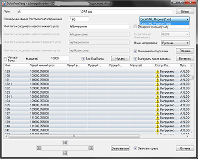
To read the data of source coordinates of raster image it is necessary to specify:
the path to the folder containing the raster images ( button Browse);
the extension of the raster image files;
data file format of the data of source coordinates;
and, in case work with Own XML Format(*.xml), the names of the tags of the coordinates of the corners.
Populating the list of data of the source coordinates of the raster images is executing after pressing the button 'Search'.
When choosing All Sub Directories search for raster images and data files of the source coordinates are executing in all subfolders of the specified folder.
Data files of the source coordinates are created by default ( in their absence), in the case work with Own XML Format(*.xml).
Current version of application ssImageInserter 2.2 supports the following data file formats of the source coordinates:
Own XML Format(*.xml);
MapInfo Format(*.tab)( Changing of the name of the tags of the coordinates of the corners for this format temporarily impossible.);
Shoosing Round Coords Values includes the option of rounding the coordinate values to the nearest value with precision from the list.
| Copyright © 2008 - 2024 |